

Software research laboratory
Long-term pursuit of modern and innovative products and services led us to software research. We work on research projects of various kinds - European, customer/commercial and internal - for more than 15 years. We have a stable, professionally focused staff and we publish the results in various periodicals. We hold the Certificate of the Ministry of Education, Science, Research and Sport on the ability to carry out science and research (certificate number 2018/2368:2-26C0) in accordance with § 26a of Act no. 172/2005 Coll. on the organization of state support for research and development and on the amendment of Act no. 575/2001 Coll. on the organization of government activities and the organization of the central state administration.
RESEARCH HOURS
IMPLEMENTED PROJECTS
RESEARCH PARTNERSHIPS
REGISTERED USE EXAMPLES


CHALLENGES WE SOLVED WITH
NEW TECHNOLOGY
WE SEE LOSS OF FERTILE SOIL THROUGH EROSION
Challenge: Water erosion is caused by flowing water in sloping and uneven terrain, on dry land, not covered by vegetation. Gravity gives it energy and it loosens, transports, and sediments the soil. It carries away the top organic matter and nutrients, and the soil becomes less fertile.
Solution: In the URANOS project, we created an application that calculates and visualizes the loss of fertile soil through erosion and determines the most appropriate agricultural measures to reduce it at the lowest possible cost. In addition to algorithms, the utility model also includes storage of external data sources and the possibility of connecting to remote devices for land management planning. This solution helps farmers, foresters, and municipalities.
Utility model no. 9599
WE SEE THREAT OF LAND SLIDES
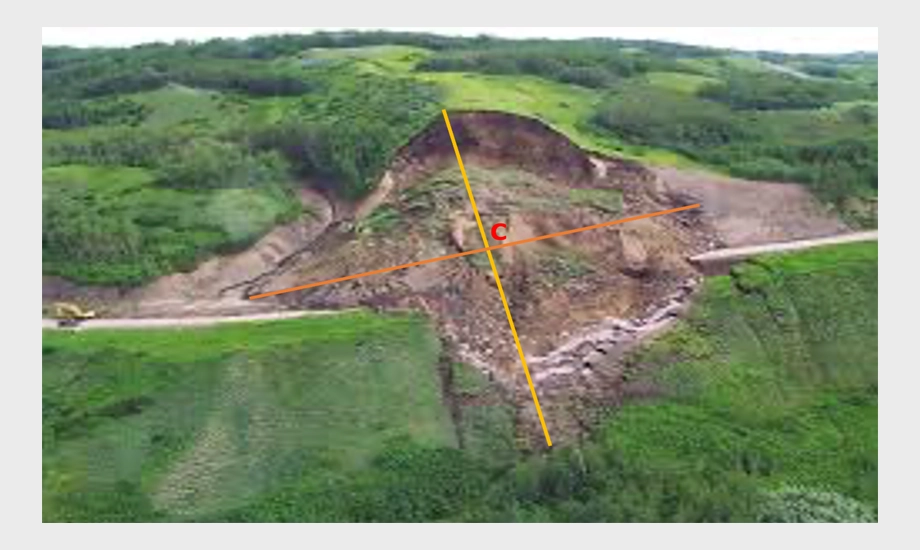
Challenge: Vertical land torrents occur during intense rainfall. The energy of running water washes away the soil, especially on slopes not protected by vegetation. They often arise in mountainous areas during logging and disturb the stability of the slopes. They can cause landslides, reduce the area suitable for forest cultivation, and reduce the possibility of handling and weighing wood. Over time, they can grow to large sizes, representing potential danger to property, or even health and lives.
Solution: In the FOMON project, we created a system that helps to automatically identify and subsequently monitor vertical torrents and their development. It analyzes remote sensing data obtained at different times and, with the help of a special algorithm, detects and visualizes the terrain in a 3D model.
Utility model no. 9971
WE SEE INVISIBLE phenomena IN INDUSTRY AREAS
Challenge: Invisible and potentially dangerous phenomena can occur in industrial areas. For example, leakage of dangerous substances causing contamination or endangering health of employees; or overheating of equipment above the limit of operating temperatures, which can be the first indicator of an impending malfunction or accident.
Solution: In the UAV project, we created a system for spatial monitoring of quantities obtained from measurements by an unmanned aerial vehicle (UAV) equipped with a quantity tracking sensor. After importing 3D point clouds, the software automatically interpolates the 3D model, which is evaluated and identifies measurement errors. The resulting clean 3D model is visualized through virtual reality and allows the end user to monitor their area or territory by moving in the virtual model.
Utility model no. 9990
RESEARCH PARTNERS


SUCCESSFUL PROJECTS

1.
ZONES OF FIELD PRODUCTIVITY
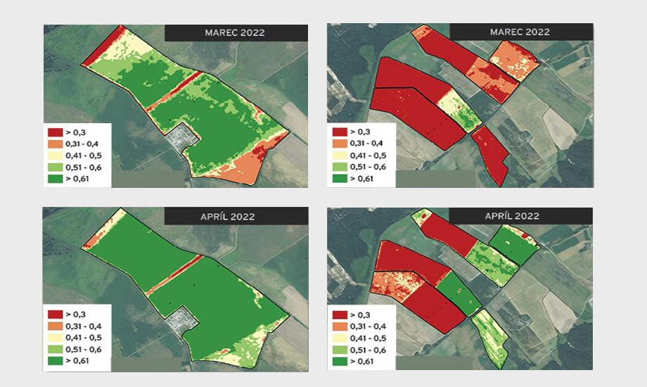
Research on the productivity of Slovak fields. Division of fields into revenue productivity zones using satellite data. Use of satellite vegetation indices with appropriate spatial and temporal resolution to identify recurring patterns of crop condition and thus productivity zones. Development of a full coverage service on a large scale, which is not yet available in Slovakia.
2.
EROSION CALCULATOR
Data and knowledge support for decision-making and strategic planning systems in the field of agricultural landscape adaptation to climate change and minimization of agricultural land degradation. Industrial research of new processing techniques, analysis and visualization of acquired data, automation and visualization of acquired data, automation of RS data, spatial modeling. Experimental development of tools for processing and publishing specific types of data. Prototypes of solutions for the collection and processing of multidimensional spatial data in different time frames and a system for innovative display of these data.


3.
NEW METHODS OF OBTAINING GEO DATA ON FORESTS
Research and development of non-contact methods for obtaining geospatial data for the purpose of forest monitoring for more efficient forest management and increased forest protection. Creation of an innovative system that identifies data in an environment of heterogeneous data sources, research into the possibilities of creating an n-dimensional data cube. Identification of new highly efficient big data evaluations for the recognition of terrain deformations under forest cover. Research into the possibilities of creating an evaluation system for categorizing dependencies that are related to predictions in forest management. Investigating the impacts of climate change on physical parameters that are key to maintaining and optimizing forest ecosystem services using the latest trends in geomatics.
4.
PROTECTION AGAINST FOREST FIRES FALCO GUARD
Identification and verification of the possibility of building a system of mobile monitoring devices designed for early detection of forest fires in currently seasonally threatened areas. Research of a mobile detection system consisting of three basic components: carriers, sensor equipment and a system for processing monitored data.


5.
MAKING INVISIBLE QUANTITIES VISIBLE
Intelligent operating and processing systems for UAVs. Research on various possibilities of using artificial intelligence to support spatial monitoring and evaluation. The research consists of creating and testing different forms of approach to environment and phenomenon modeling, using machine learning tools, n-dimensional fractal geometry, geo-statistics and other progressive methods.
6.
SPACE TRANSLATOR
Monitoring and mapping the condition of the forest cover using data from the Sentinel 2 satellite. We created a modern tool for automated downloading, processing and evaluation of data from satellite imaging of the Earth's surface, universally usable for various segments of the economy, which we deployed and tested in the forestry domain as part of the project to identify attack of the growth by lycophagus.


7.
RISK AND VECTORS OF TOXICITY SPREAD IN THE SOIL
Remediation of the environment in zones contaminated by the activities of the armed forces. We tested ecological methods of cleaning contaminated soil from toxins, mainly from dangerous arsenic and zinc. Specially mixed regeneration substrates and the use of soy, which binds toxins from the soil, brought promising results. We created a digital model of the spread of toxins on the spatial decision management platform, yDecision.
8.
MODELING OF LANDSLIDE PATHS IN vratna dolina
Modeling of debris flows in Vrátná dolina. We created a model of debris flows in Vrátná dolina using the technology of aerial laser scanning and sophisticated spatial analyzes (PROXIMA technology). We have created a digital model of the terrain and its visualization in different ways. We validated the modeling by comparing the modeling data with field survey data. Additional data were used in the form of orthophotos.


9.
LASER SCANNING OF THE MOLPÍR archaeological site
Airbone laserscan archaeological survey "Revitalization of the hillfort on Molpír". Using the technology of aerial laser scanning and sophisticated spatial analyzes (PROXIMA technology), we discovered previously undiscovered archaeological structures in an area relatively well explored by standard field methods. We acquired and processed data with the help of a leveled flight path with the creation of orthophotos, we created a digital model of the terrain and its visualization in various ways.
10.
INTELLIGENT TRANSPORT SYSTEMS
Technology for research in the field of Intelligent Transport Systems and Progressive Materials. We delivered the Virtual smart city system or Virtual city according to the customer's specification. We ensured mutual communication between individual parts of the Integrated Transport System and the Virtual City subsystem, including the Monitoring and Control System subsystem.
11.
AIR TRANSPORT BROKER CENTER
Air transport broker center for technology and knowledge transfer to transport and transport infrastructure. We have created a data repository for large sets of data obtained from aerial laser scanning of the Earth's surface. We have transferred knowledge and technology from location services research to the transportation industry. Subsequently, we developed a brokerage center for analytical data processing and knowledge acquisition.


